
1. What you can do with GPS Data Parser
- document your jogging, hiking, biking, boating, gliding or flying trips on satellite images or topographical maps,
- calculate distances, speeds, plot altitude profiles using spreadsheet or other mathematical programs.
2. Features
- document your jogging, hiking, biking, boating, gliding or flying trips on satellite images or topographical maps,
- calculate distances, speeds, plot altitude profiles using spreadsheet or other mathematical programs.
- V6.1b and upwards accepts input files with the following
position data:
$GPGGA, $GPGLL and $GPRMC (can be mixed),
GPX track data,
IGC flight recorder files (view sample track plot on Google Earth),
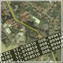
- Writes space-separated output tables containing time in seconds, latitude, longitude and altitude (if available), suitable for the use with spread sheet programs, such as MS Excel (view boat speed profile and flight altitude profiles in the examples page).
- Altitude data can be corrected or manipulated,
- Position values are written in degrees with decimal places,
- Choice of decimal point or decimal comma (e.g. for European users)
- Can produce KML files for track plots onto GOOGLE Earth® maps with adjustable parameters
- Can produce GeoGrid® OVL files for track plot overlays on topographical maps, e.g. TOP 50 or TOP 200 (GeoGrid® is a product of EADS).
The program was initialy developed to
convert GPS and logs of other navigation systems for the use
with the author's
NavGen
algorithm.
3. GPS Data Parser Program
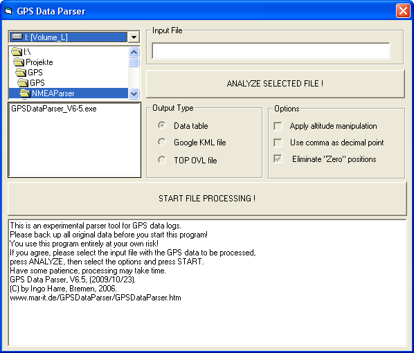
4. Program Download
The program can be downloaded by clicking on the link below. If you do not have it already on your computer, you will need the Visual Basic 6.0 runtime file MSVBVM60.DLL, which can be downloaded from Microsoft. My program can be used freely for personal and non-commercial use. Any other use requires my formal agreement. The program is experimental and you will use it entirely at your own risk. If you have understood this and agree, you may now download the program. The current version is V6.5 of 2009/10/23
Ingo Harre, Bremen, Germany, Content last modified on 2009/10/21